Skip to content
ParkuzaPrint a map ↗
PARK MAP

White Sands National Park Map

White Sands protects a large portion of the gypsum dune landscape in New Mexico's Tularosa Basin. The bright dunes support plants and animals adapted to this unusual desert environment.

Best timeMar, Apr, Oct, Nov
Time to explore1 days
Entrance$25 · private vehicle
Entry planningCheck date-specific access
Explore park map ↓Fees & reservationsPlan your visit, one place at a time.
National park

Things to do

HikingCampingCyclingRanger programsPhotographyPicnicking

Best for

PhotographersCouplesSolo travelersFamiliesRoad tripsSpecific accessible facilities

Experiences

Desert

Seasons

SpringFall

Visit length

4 hours1 day2 days

Plan ahead

Entrance chargeMapped campgroundsMapped lodgingSome reservations / permits
AROUND THE PARK

Stay, refuel & explore nearby

Find nearby towns, places to stay and useful services for your national park trip. Distances are approximate straight lines from the park boundary or map center, not driving distances.

Nearby towns 6

Local nearby towns to consider when planning your park visit.

Holloman AFB, NM

Approx. 3.3 mi / 5.4 km from park boundary · straight line

Nearby town. Choose a specific park entrance when planning your approach.

Boles Acres, NM

Approx. 9.7 mi / 15.7 km from park boundary · straight line

Nearby town. Choose a specific park entrance when planning your approach.

Alamogordo, NM

Approx. 11.0 mi / 17.7 km from park boundary · straight line

Nearby town. Choose a specific park entrance when planning your approach.

La Luz, NM

Approx. 14.1 mi / 22.7 km from park boundary · straight line

Nearby town. Choose a specific park entrance when planning your approach.

Tularosa, NM

Approx. 16.0 mi / 25.8 km from park boundary · straight line

Nearby town. Choose a specific park entrance when planning your approach.

High Rolls, NM

Approx. 20.7 mi / 33.4 km from park boundary · straight line

Nearby town. Choose a specific park entrance when planning your approach.

Hotels / lodging 5

Local hotels / lodging to consider when planning your park visit.

Holloman Inn

Approx. 3.8 mi / 6.2 km from park boundary · straight line

1040 New Mexico Ave, Holloman Air Force Base, NM, 88330-8159, US

WebsiteCall

Holiday Inn Express & Suites Alamogordo by IHG

Approx. 11.1 mi / 17.8 km from park boundary · straight line

100 Kerry Ave, Alamogordo, NM, 88310, US

WebsiteCall

Hampton Inn Alamogordo

Approx. 11.1 mi / 17.9 km from park boundary · straight line

1295 Hamilton Rd, Alamogordo, NM, 88310, US

WebsiteCall

Tavares Inn

Approx. 11.2 mi / 18.0 km from park boundary · straight line

153 San Pedro Dr, Alamogordo, NM, 88310, US

WebsiteCall

Americas Best Value Inn

Approx. 11.2 mi / 18.0 km from park boundary · straight line

1401 S White Sands Blvd, Alamogordo, NM, 88310, US

WebsiteCall

Restaurants 5

Local restaurants to consider when planning your park visit.

Domino's

Approx. 4.3 mi / 7.0 km from park boundary · straight line

744 First Street Building 33, Holloman Air Force Base, NM, 88330, US

WebsiteCall

The 19th Hole Grill & Bar

Approx. 11.1 mi / 17.8 km from park boundary · straight line

2351 Hamilton Rd, Alamogordo, NM, 88310, US

WebsiteCall

Wingstop

Approx. 11.1 mi / 17.9 km from park boundary · straight line

1300 S . White Sands Blvd Suite B, Alamogordo, NM, 88310, US

WebsiteCall

Chili's Grill & Bar

Approx. 11.1 mi / 17.9 km from park boundary · straight line

202 Panorama Dr., Alamogordo, NM, 88310-7215, US

WebsiteCall

The Burger Den

Approx. 11.1 mi / 17.9 km from park boundary · straight line

806 S. White Sands Blvd., Alamogordo, NM, 88310, US

WebsiteCall

Grocery 5

Local grocery to consider when planning your park visit.

Holloman Commissary

Approx. 4.1 mi / 6.6 km from park boundary · straight line

751 W New Mexico Ave, Holloman Air Force Base, NM, 88330, US

WebsiteCall

Aikos Oriental Food

Approx. 11.5 mi / 18.5 km from park boundary · straight line

700 E 1st St, Alamogordo, NM, 88310, US

Call

Lowe's Signature Market

Approx. 11.7 mi / 18.8 km from park boundary · straight line

675 E 10th St, Alamogordo, NM, 88310, US

WebsiteCall

Albertsons Market

Approx. 12.1 mi / 19.6 km from park boundary · straight line

1300 E 10th St, Alamogordo, NM, 88310, US

WebsiteCall

Walmart Neighborhood Market

Approx. 13.2 mi / 21.3 km from park boundary · straight line

2401 Indian Wells Road, Alamogordo, NM, 88310, US

WebsiteCall

Fuel 5

Local fuel to consider when planning your park visit.

Chevron Station Alamogordo

Approx. 9.2 mi / 14.9 km from park boundary · straight line

1445 Highway 70 W, Alamogordo, NM, 88310, US

Call

Texaco Station Alamogordo

Approx. 10.0 mi / 16.1 km from park boundary · straight line

901 Highway 70 W, Alamogordo, NM, 88310, US

WebsiteCall

Giant

Approx. 10.7 mi / 17.3 km from park boundary · straight line

1957 Highway 54 S, Alamogordo, NM, 88310-7377, US

WebsiteCall

Murphy USA

Approx. 11.2 mi / 18.1 km from park boundary · straight line

221 S White Sands Blvd, Alamogordo, NM, 88310, US

WebsiteCall

Murphy Express

Approx. 11.2 mi / 18.1 km from park boundary · straight line

221 S. White Sands Boulevard, Alamogordo, NM, 88310, US

Airports 3

Local airports to consider when planning your park visit.

Alamogordo-White Sands Regional Airport

Approx. 9.2 mi / 14.9 km from park boundary · straight line

3500 Airport Rd, Alamogordo, NM, 88310, US

WebsiteCall

Las Cruces International Airport

Approx. 38.2 mi / 61.5 km from park boundary · straight line

8990 Zia Blvd, Las Cruces, NM, 88007, US

WebsiteCall

Sierra Blanca Regional Airport

Approx. 54.2 mi / 87.2 km from park boundary · straight line

1041 State Highway 48, Capitan, NM, 88316, US

WebsiteCall

Hospitals / pharmacies 5

Local hospitals / pharmacies to consider when planning your park visit.

Walgreens Pharmacy

Approx. 11.3 mi / 18.1 km from park boundary · straight line

955 N White Sands Blvd, Alamogordo, NM, 88310, US

WebsiteCall

Community Connections

Approx. 12.8 mi / 20.6 km from park boundary · straight line

1859 Indian Wells Rd, Alamogordo, NM, 88310, US

Call

Harvey PFlanzer, DO

Approx. 13.2 mi / 21.2 km from park boundary · straight line

2669 Scenic Dr, Alamogordo, NM, 88310, US

WebsiteCall

Christus Southern New Mexico

Approx. 13.2 mi / 21.2 km from park boundary · straight line

2669 Scenic Drive, Alamogordo, NM, 88310, US

WebsiteCall

Women's Specialty Services

Approx. 13.5 mi / 21.7 km from park boundary · straight line

2050 N Scenic Dr, Alamogordo, NM, 88310, US

WebsiteCall
YOUR PARK MAP GUIDE

Plan your visit with the White Sands National Park map

White Sands protects a large portion of the gypsum dune landscape in New Mexico's Tularosa Basin. The bright dunes support plants and animals adapted to this unusual desert environment.

Use this White Sands map to choose an approach, reveal place categories and group stops into a realistic day. Temporary access closures can occur for nearby missile testing. The dunes road and walking conditions change with weather.
Suggested monthsMar, Apr, Oct, Nov
Entrance fee$25 · private vehicle
Plan your time1 day guide
Map accessDrive access
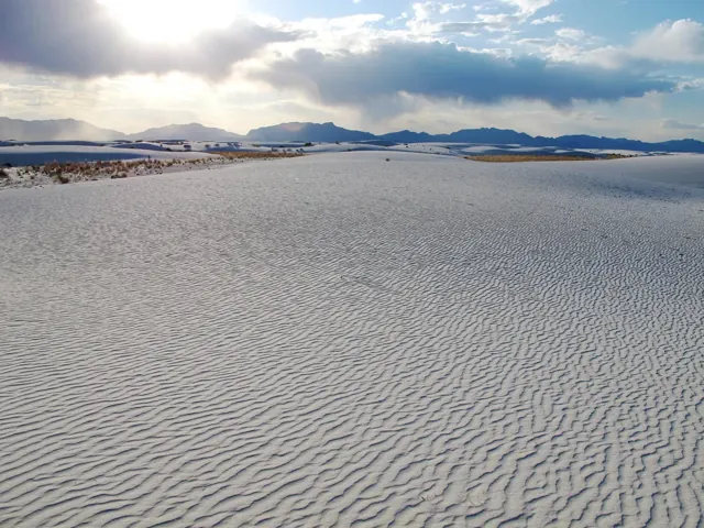
White dunes in foreground with sun setting behind mountain.

Best months and weather

Spring and fall often avoid the strongest summer heat. Wind and bright reflective sand affect comfort.

  • Jan
  • Feb
  • Mar
  • Apr
  • May
  • Jun
  • Jul
  • Aug
  • Sep
  • Oct
  • Nov
  • Dec

Highlighted months are an editorial guide for a general visit. Conditions vary by elevation and activity.

Weather to plan for

Summer can be very hot, winter evenings cool, and spring windy. Conditions vary widely through the year, so use the forecast when planning time on the dunes.

Seasonal access

Temporary access closures can occur for nearby missile testing. The dunes road and walking conditions change with weather.

Before you set out

Check the date on saved information. Road, trail and weather conditions can change after a map is downloaded.

Things to do in White Sands

HikingCampingCyclingRanger programsPhotographyPicnicking

Choose from hiking, camping, cycling, ranger programs. Match each activity to the season, your group’s ability and the access requirements for that particular place.

A practical White Sands day plan

Check the day's access window, explore during cooler hours and set a clear turnaround. Carry water and navigation awareness on open dunes.

Build your park day on the map

Entrances, parking and getting around

White Sands National Park is located off of US Highway 70 between the cities of Las Cruces and Alamogordo. The park is about 15 miles west of Alamogordo and 52 miles east of Las Cruces.

Choose your approach

Check official conditions before travel. Directory-listed locations are not a guarantee of current opening or road access.

Parking, shuttles and facilities

Use the parking and shuttle layers to see the locations included in this map edition. A mapped space or stop does not confirm capacity, a timetable or present-day operation.

Offline planning

Save this park map while connected. Your saved plan stays in this browser; export a backup before changing devices.

Entrance fees and visit costs

$25 · private vehicle

Camping, transport, tours and reservations can cost extra. Pass coverage and group eligibility vary.

ChargeUSDBasis
Private vehicle$25.00Valid for 7 days
Per person$15.00Valid for 7 days
Motorcycle$20.00Valid for 7 days

Fee snapshot checked 2026-10-05. Camping, reservations, tours and transport can cost extra. Amounts are planning information, not a booking quote.

What you can find on the park map

Toggle a category to show its icons. Empty categories mean no mapped location is included in this edition. Use the list alternative to select every mapped point.

CHOOSE YOUR SEASON

Your month-by-month park map

These are planning suggestions, not forecasts or live crowd measurements. Select a month for its details.

JanVariable

Weather & access

Summer can be very hot, winter evenings cool, and spring windy. Conditions vary widely through the year, so use the forecast when planning time on the dunes.

Planning your visit

Temporary access closures can occur for nearby missile testing. The dunes road and walking conditions change with weather.

No live crowd measurement is included. Allow time for parking, transport and popular stops.

FebVariable

Weather & access

Summer can be very hot, winter evenings cool, and spring windy. Conditions vary widely through the year, so use the forecast when planning time on the dunes.

Planning your visit

Temporary access closures can occur for nearby missile testing. The dunes road and walking conditions change with weather.

No live crowd measurement is included. Allow time for parking, transport and popular stops.

MayVariable

Weather & access

Summer can be very hot, winter evenings cool, and spring windy. Conditions vary widely through the year, so use the forecast when planning time on the dunes.

Planning your visit

Temporary access closures can occur for nearby missile testing. The dunes road and walking conditions change with weather.

No live crowd measurement is included. Allow time for parking, transport and popular stops.

JunVariable

Weather & access

Summer can be very hot, winter evenings cool, and spring windy. Conditions vary widely through the year, so use the forecast when planning time on the dunes.

Planning your visit

Temporary access closures can occur for nearby missile testing. The dunes road and walking conditions change with weather.

No live crowd measurement is included. Allow time for parking, transport and popular stops.

JulVariable

Weather & access

Summer can be very hot, winter evenings cool, and spring windy. Conditions vary widely through the year, so use the forecast when planning time on the dunes.

Planning your visit

Temporary access closures can occur for nearby missile testing. The dunes road and walking conditions change with weather.

No live crowd measurement is included. Allow time for parking, transport and popular stops.

AugVariable

Weather & access

Summer can be very hot, winter evenings cool, and spring windy. Conditions vary widely through the year, so use the forecast when planning time on the dunes.

Planning your visit

Temporary access closures can occur for nearby missile testing. The dunes road and walking conditions change with weather.

No live crowd measurement is included. Allow time for parking, transport and popular stops.

SepVariable

Weather & access

Summer can be very hot, winter evenings cool, and spring windy. Conditions vary widely through the year, so use the forecast when planning time on the dunes.

Planning your visit

Temporary access closures can occur for nearby missile testing. The dunes road and walking conditions change with weather.

No live crowd measurement is included. Allow time for parking, transport and popular stops.

DecVariable

Weather & access

Summer can be very hot, winter evenings cool, and spring windy. Conditions vary widely through the year, so use the forecast when planning time on the dunes.

Planning your visit

Temporary access closures can occur for nearby missile testing. The dunes road and walking conditions change with weather.

No live crowd measurement is included. Allow time for parking, transport and popular stops.

MAKE TIME FOR THE GOOD PART

How long do you have?

4 hours

A focused introduction

Choose one compact area and keep the route short. Check the day's access window, explore during cooler hours and set a clear turnaround. Carry water and navigation awareness on open dunes.

Focus: Temporary access closures can occur for nearby missile testing. The dunes road and walking conditions change with weather.

Build this park day →
1 day

One area, one memorable day

Use a single entrance or arrival area and group nearby stops. A one-day plan is a selective introduction. Check the day's access window, explore during cooler hours and set a clear turnaround. Carry water and navigation awareness on open dunes.

Focus: Temporary access closures can occur for nearby missile testing. The dunes road and walking conditions change with weather.

Build this park day →
2 days

Two days to settle in

Use the first day for an accessible introduction and a second day for a distinct area or longer activity. Check the day's access window, explore during cooler hours and set a clear turnaround. Carry water and navigation awareness on open dunes.

Focus: Temporary access closures can occur for nearby missile testing. The dunes road and walking conditions change with weather.

Build this park day →
BEFORE YOU ADD IT TO YOUR TRIP

Reservations, permits & bookings

Park entry & access

Check date-specific access

Temporary access closures can occur for nearby missile testing. The dunes road and walking conditions change with weather. Review entry, transport and activity bookings for your dates; a map icon is not a reservation.

Verify for your travel dates

Camping example: Backcountry Camping

Rules vary by campground

Permits are sold on a same day, first-come, first-served basis at the entrance station. Confirm the rules for your chosen campground and dates.

Record checked 2026-10-05

Activities & permits

Activity-specific requirements

Choose from hiking, camping, cycling, ranger programs. Match each activity to the season, your group’s ability and the access requirements for that particular place. An entrance pass does not replace a tour ticket, campsite booking or activity permit.

Record checked 2026-10-05

Make the visit work for you

Families & children

Choose short, manageable activities for your group. Check the day's access window, explore during cooler hours and set a clear turnaround. Carry water and navigation awareness on open dunes.

Bringing a pet

Pet access is area-specific. Check the exact trail, campground and transport rules before bringing an animal; the map does not label the whole park pet friendly. Service-animal rules differ from pet rules.

Accessibility

Directory-listed wheelchair-accessible facilities include White Sands Visitor Center. These can be outside the park boundary. Choose specific facilities and check surfaces, grades, restrooms and transport before travel; a general park tag does not establish accessibility.

Before you set out

Summer can be very hot, winter evenings cool, and spring windy. Conditions vary widely through the year, so use the forecast when planning time on the dunes. Temporary access closures can occur for nearby missile testing. The dunes road and walking conditions change with weather.

Explore nearby national park maps

Nearest park reference points by straight-line distance. Roads, water crossings and travel time are different.

White Sands map questions

What weather should I prepare for at White Sands?

Summer can be very hot, winter evenings cool, and spring windy. Conditions vary widely through the year, so use the forecast when planning time on the dunes.

How does NPS describe getting to White Sands?

White Sands National Park is located off of US Highway 70 between the cities of Las Cruces and Alamogordo. The park is about 15 miles west of Alamogordo and 52 miles east of Las Cruces. Check the official directions page for current routing details.

What access features does NPS describe at White Sands Visitor Center?

NPS lists these access features: Braille, Restroom - Accessible, Wheelchair Accessible. This describes that facility, not the accessibility of every area of the park.

Where does NPS list visitor information for White Sands?

The NPS directory lists White Sands Visitor Center. The visitor center was built in 1936 and is part of the historic district at White Sands. Inside you will find the park store as well as the museum for the park. Check the linked park information before relying on opening hours or services.

Make the map yours

Keep a wishlist, mark parks visited and save named trips in this browser. Export a backup before changing devices.

Open My Parks →

Take your map with you

Create a clean PDF or PNG with a map, numbered park legend and checklist. National exports include Alaska, Hawaii and the territories.

Open Print Studio →