Culebra zona urbana, PR
Approx. 23.8 mi / 38.4 km from park boundary · straight line
Nearby town. Choose a specific park entrance when planning your approach.
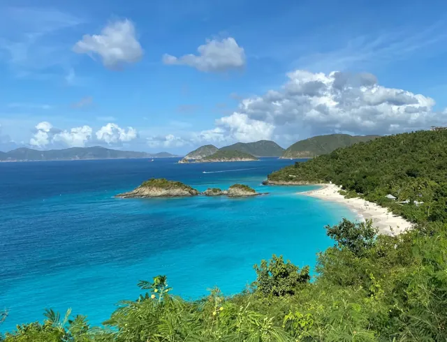
Virgin Islands National Park combines St. John's beaches and coral reefs with trails to plantation sites and Indigenous petroglyphs. Its cultural history includes both Indigenous life and the legacy of enslaved labor.
Find nearby towns, places to stay and useful services for your national park trip. Distances are approximate straight lines from the park boundary or map center, not driving distances.
Local nearby towns to consider when planning your park visit.
Approx. 23.8 mi / 38.4 km from park boundary · straight line
Nearby town. Choose a specific park entrance when planning your approach.
Approx. 35.5 mi / 57.1 km from park boundary · straight line
Nearby town. Choose a specific park entrance when planning your approach.
Approx. 38.8 mi / 62.5 km from park boundary · straight line
Nearby town. Choose a specific park entrance when planning your approach.
Approx. 45.3 mi / 73.0 km from park boundary · straight line
Nearby town. Choose a specific park entrance when planning your approach.
Approx. 45.8 mi / 73.7 km from park boundary · straight line
Nearby town. Choose a specific park entrance when planning your approach.
Approx. 46.7 mi / 75.2 km from park boundary · straight line
Nearby town. Choose a specific park entrance when planning your approach.
Local hotels / lodging to consider when planning your park visit.
Local restaurants to consider when planning your park visit.
Approx. 2.8 mi / 4.5 km from park boundary · straight line
6910 Great Bay, Nazareth, East End, 00802, VI
No nearby places match your search.
Virgin Islands National Park combines St. John's beaches and coral reefs with trails to plantation sites and Indigenous petroglyphs. Its cultural history includes both Indigenous life and the legacy of enslaved labor.
Use this Virgin Islands map to choose an approach, reveal place categories and group stops into a realistic day. Island transport, steep roads and beach parking require planning. Some facilities or beaches have separate charges.
The generally drier winter and spring season can suit beach and trail visits. Marine conditions are always local.
Highlighted months are an editorial guide for a general visit. Conditions vary by elevation and activity.
Trade winds shape the tropical climate. Winter is generally windier and drier, summer rainier, and hurricane weather or ocean swell can affect plans.
Island transport, steep roads and beach parking require planning. Some facilities or beaches have separate charges.
Check the date on saved information. Road, trail and weather conditions can change after a map is downloaded.
Choose from hiking, boating, fishing, snorkeling, ranger programs. Match each activity to the season, your group’s ability and the access requirements for that particular place.
Group a beach and nearby trail, matching swimming and snorkeling to current sea conditions. Leave time for your island transport connections.
Build your park day on the mapThere are no airports on St. John so you must fly to the St. King Airport (code STT) and travel from there. From the airport you rent a car and drive or take a taxi to Redhook (west end) St. From there you can either take a car barge to St. John or the people ferry. John you can easily walk from the ferry terminal to the Visitor Center.
Check official conditions before travel. Directory-listed locations are not a guarantee of current opening or road access.
Use the parking and shuttle layers to see the locations included in this map edition. A mapped space or stop does not confirm capacity, a timetable or present-day operation.
Save this park map while connected. Your saved plan stays in this browser; export a backup before changing devices.
$0 · general entrance
No general park entrance fee. Trunk Bay has a separate amenity charge; transport and visitor services can cost extra.
| Charge | USD | Basis |
|---|---|---|
| General entrance | $0.00 | No general park entrance fee. Trunk Bay has a separate amenity charge; transport and visitor services can cost extra. |
Fee snapshot checked 2026-10-05. Camping, reservations, tours and transport can cost extra. Amounts are planning information, not a booking quote.
Toggle a category to show its icons. Empty categories mean no mapped location is included in this edition. Use the list alternative to select every mapped point.
These are planning suggestions, not forecasts or live crowd measurements. Select a month for its details.
Use a single entrance or arrival area and group nearby stops. A one-day plan is a selective introduction. Group a beach and nearby trail, matching swimming and snorkeling to current sea conditions. Leave time for your island transport connections.
Focus: Island transport, steep roads and beach parking require planning. Some facilities or beaches have separate charges.
Build this park day →Give separate areas their own days and build in room for weather and transfers. Group a beach and nearby trail, matching swimming and snorkeling to current sea conditions. Leave time for your island transport connections.
Focus: Island transport, steep roads and beach parking require planning. Some facilities or beaches have separate charges.
Build this park day →Use a base or carefully planned transfers to explore more deeply, with a flexible weather day. Group a beach and nearby trail, matching swimming and snorkeling to current sea conditions. Leave time for your island transport connections.
Focus: Island transport, steep roads and beach parking require planning. Some facilities or beaches have separate charges.
Build this park day →Island transport, steep roads and beach parking require planning. Some facilities or beaches have separate charges. Review entry, transport and activity bookings for your dates; a map icon is not a reservation.
Verify for your travel datesReserve your campsite at the website linked below. Confirm the rules for your chosen campground and dates.
Record checked 2026-10-05Choose from hiking, boating, fishing, snorkeling, ranger programs. Match each activity to the season, your group’s ability and the access requirements for that particular place. An entrance pass does not replace a tour ticket, campsite booking or activity permit.
Record checked 2026-10-05Choose short, manageable activities for your group. Group a beach and nearby trail, matching swimming and snorkeling to current sea conditions. Leave time for your island transport connections.
Pet access is area-specific. Check the exact trail, campground and transport rules before bringing an animal; the map does not label the whole park pet friendly. Service-animal rules differ from pet rules.
Directory-listed wheelchair-accessible facilities include Cruz Bay Visitor Center. These can be outside the park boundary. Choose specific facilities and check surfaces, grades, restrooms and transport before travel; a general park tag does not establish accessibility.
Trade winds shape the tropical climate. Winter is generally windier and drier, summer rainier, and hurricane weather or ocean swell can affect plans. Island transport, steep roads and beach parking require planning. Some facilities or beaches have separate charges.
Nearest park reference points by straight-line distance. Roads, water crossings and travel time are different.
Trade winds shape the tropical climate. Winter is generally windier and drier, summer rainier, and hurricane weather or ocean swell can affect plans.
There are no airports on St. John so you must fly to the St. King Airport (code STT) and travel from there. From the airport you rent a car and drive or take a taxi to Redhook (west end) St. From there you can either take a car barge to St. John or the people ferry. John you can easily walk from the ferry terminal to the Visitor Center. Check the official directions page for current routing details.
NPS lists these access features: Restroom - Accessible, Wheelchair Accessible. This describes that facility, not the accessibility of every area of the park.
The NPS directory lists Cruz Bay Visitor Center. Visitor and Information Center for Virgin Islands National Park and Virgin Islands Coral Reef National Monument. Check the linked park information before relying on opening hours or services.
Keep a wishlist, mark parks visited and save named trips in this browser. Export a backup before changing devices.
Open My Parks →Create a clean PDF or PNG with a map, numbered park legend and checklist. National exports include Alaska, Hawaii and the territories.
Open Print Studio →